
A cutting-edge tool for rapid and effective landslide detection
The tool is based on Deep Neural Networks (DNNs) and Synthetic Aperture Radar (SAR) backscatter data. Lorenzo Nava, Kushanav Bhuyan and Filippo Catani are among the contributors
23.04.2024
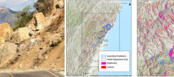
On April 3, a magnitude 7.4 earthquake struck Hualien, Taiwan. Following the earthquake, landslides, rather than building collapses, have caused significant devastation. However, due to persistent cloud cover, the precise locations of many landslides remain unknown. To address this challenge, an international team of researchers has developed a tool leveraging Sentinel-1 Synthetic Aperture Radar (SAR) backscatter data, and Deep Neural Networks, enabling landslide detection even in cloudy conditions.
The tool has been successfully deployed in Taiwan, yielding a first mapping of slope changes triggered by the earthquake. Furthermore, with some affected areas now clear of clouds on optical PlanetScope imagery, we've obtained partial validation, as showed in the attached figures.
Predictions repository: https://drive.google.com/drive/u/0/folders/1NYygnItQbQU6K3GmtOPBiXuE_zRIsehg
Preprint link: https://eartharxiv.org/repository/view/6937/
Code link: https://github.com/lorenzonava96/SAR-and-DL-for-Landslide-Rapid-Assessment
The landslide detection from SAR ascending data became available on April 8th, followed by the descending orbit detection on April 10th. Although optical images, such as PlanetScope, offer cloud-free coverage in limited areas, facilitating validation of SAR-based detection, SAR provides a comprehensive overview, revealing the areas with the highest density of landslides all over the area affected by the earthquake, regardless of the still extant cloud cover.