
Virtual reality and its practical applications for research and teaching
The new Environmental Geology and Earth Dynamics master's degree includes some courses, such as Geology and Exploration of Planetary Bodies and Digital Geological Mapping, in which immersive virtual reality can be fruitfully applied. The use of such technologies has enormous advantages for nowadays geologists.
It is not unusual that once back at home after a field campaign of some weeks even in a remote place, a geologist might realize to still need more or of a better quality data. The feeling is very similar to the one perceived when once arrived at your destination, you start thinking that you might have left the front door open or the gas turned on. You can not close the door just wearing an Oculus and projecting yourselves in virtual reality, but for sure you can measure bedding, faults, and fracture orientations in this way.
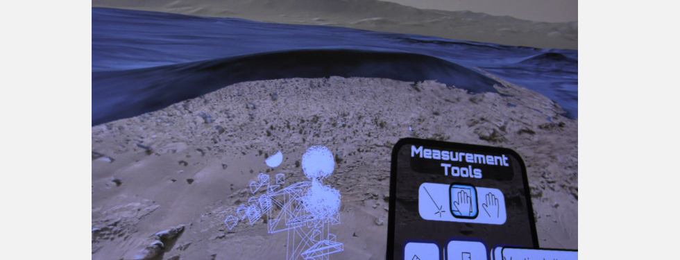
Nowadays robotic vehicles allow to reach and observe areas of difficult or even impossible access. Think about the acquisitions of high vertical walls with unmanned air vehicles or of deep marine floors with submarine drones or even the Martian or Lunar landscapes acquired by rovers equipped with highly performing payloads. All these acquisitions enable 3-dimensional environments to be reconstructed and their use in an immersive virtual reality context allows the geologist to operate in his/her laboratory as he/she was hovering in front of a vertical wall or diving in deep water while studying the ocean floors or, even at 290 million kilometers far away, analyzing rocks outcropping at the Martian surface.
In summary, virtual reality allows at any moment access to any environment previously acquired in 3D. We can really affirm that today a geologist can bring a mountain, where ever it is, at home and study it whenever he/she prefers.
Colleagues and students from all over the world can meet in a virtual reality landscape following the expert of that geological context explaining the related stratigraphy and geological structures.
During the Virtual Winter School in Geology and Planetary Mapping, organized in 2021 by the EPN2024-GMap infrastructure led by the Department of Geosciences of the University of Padua, the VR advantages were illustrated to students from 30 countries all over the world. On that occasion, the virtual experience has been carried out on a Martian environment reconstructed by the H2020-PlanMap project, again coordinated by the University of Padua.
This year within the course on Geology and Exploration of Planetary bodies and in the Erasmus Mundus strategic partnership framework, a large group of professors and students of the Universities of Nantes, Coimbra, Porto, and Padua met all together in the virtual landscape of Mars to study the Kimberly outcrop in Gale crater which was visited by the Curiosity rover. To our knowledge, this is the first time that a synchronous collaborative field experience was carried out in a virtual environment among different Universities.
Finally, the Digital Geological Mapping course is specifically dedicated to the reconstruction of 3D photogrammetric models of outcropping rock- bodies and to their analysis using dedicating software even enabling analysis in immersive virtual reality.