
DAEDALUS, the sphere to map lunar caves, is elected "Technology Image of the Week" by ESA
The tool, developed with the collaboration of the Department of Geosciences and CISAS, is being evaluated by the ESA's Concurrent Design Facility to be introduced in the next missions on our satellite
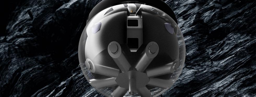
A sphere of 46 centimeters in diameter with all the necessary instrumentation inside to map the lunar caves. This is the description of DAEDALUS (Descent And Exploration in Deep Autonomy of Lunar Underground Structures), the tool chosen by the European Space Agency (ESA) as "Technology Image of the Week" and developed by an international consortium to which also the Department of Geosciences and the University Center for Space Studies and Activities "Giuseppe Colombo" - CISAS collaborate.
Developed in over 15 months within the ESA's Open Space Innovation Platform, DAEDALUS will allow the three-dimensional mapping of lunar cavities, as explained by Matteo Massironi, Associate Professor in Structural Geology at the Department of Geosciences and supervisor of the project in its Paduan component. "DAEDALUS will be equipped with four hyper-hemispheric cameras developed by INAF, the Italian Institute fpr AstroPhysics, that will provide an immersive 360° view during the descent in the cave. We also complement to the cameras the presence of two LIDARs at different wavelengths that will allow to map the shadowed areas and the likely lava tunnel". Sabrina Ferrari from CISAS adds that “this instrumentation will also help us to characterize the mineralogy of the basaltic walls and of the paleo-soils trapped in between them, and will also provide information about the presence of water and titanium-rich minerals such as ilmenite.”
"The importance of the exploration of lunar cavities has strong repercussions on future missions", underlines Dr. Riccardo Pozzobon of CISAS, "because, if accessible, they could provide shelter from solar/cosmic radiation, micro-meteorites impact and a controlled-temperature environment. This will be useful for both materials’ storage and human settlements. To date, we do not have direct knowledge of such lava tubes, their inner morphology and how they develop in the lunar subsurface. We only know the access points, the so-called skylights pits, and that the voids below could reach dimensions of up to 1 billion cubic meters". Moreover, as explained by Francesco Maurelli from Jacobs University, who designed the locomotion of the sphere, “the robot is capable of semi-autonomous navigation, and its spherical shape together with the presence of 16 extensible pods will allow a certain degree of freedom in attempting to navigate in the interior of the cave”.
And just in these days the study phase of the "Concurrent Design Facility" is being concluded, in which a team of ESA experts has provided their expertise in the dimensioning of the sphere itself and of the robotic crane (developed by the consortium of the Universities of Vigo and Oviedo) necessary to lower the instrument into the lunar cavities.
The DAEDALUS consortium is led by the Julius Maximilians University of Wurzburg (Germany) for the robotic and laser scanner part, with the contribution of the University of Padua (CISAS and Department of Geosciences) for the part of characterization of the landing site and definition of scientific requirements. Other partners of the consortium are INAF Padua for the optical cameras, Jacobs University of Bremen (Germany) for the locomotion systems, the Italian Aerospace Research Center (CIRA) for the study of the materials that make up the transparent sphere, and the VIGEA company in Reggio Emilia for advice on laser scanners in the cave.